One of the TH&B's most interesting attributes is its compactness. From end to end, the railroad is full of compact scenes that lend themselves well to modeling. And as I've done more research into certain scenes, I've found that it's not just the track arrangements and the operations that make the scenes interesting - the way these places illustrate the nature of an era make them truly fascinating.
Brantford is one of those fascinating places. In a little over a mile you can find an amazing arrangement of track: a wye, two very compact yards, a nice selection of heavy industry, a surprising number of smaller industries, a C.N.R. interchange, an interchange with an interurban line and an impressive river crossing.
Looking at the history, you find over that same distance names that helped to define Canadian industry in the early 20th century: Massey-Harris, Cockshutt, Waterous and others. In its heyday, over 20,000 people worked along this stretch of track. At one time, there was a level of activity in this area that is difficult to imagine today.
I've designed a small bedroom-sized model railroad based on the main section of Brantford Yard between Eagle Avenue and Market Street. My goal is to capture the look and feel of Brantford Yard in the first half of the 20th century. By varying the motive power and rolling stock on the layout, I hope to represent scenes and operations from 1916 up to 1954.
Resources
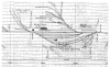
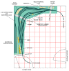
This layout design has evolved through many different stages as I discovered information about the area. The first resource I came across was the diagram shown in Figure 1. Figure 1 is part of the track diagrams submitted to Focus by Angus Palmer. These diagrams provide a schematic of the entire railway from Welland to Waterford. Figure 1 shows the overall arrangement of Brantford Yard between Eagle Avenue and Market Street.
The area shown in the diagram is just over one-third of a mile in length - from Mile 62.20 at Eagle Avenue to Mile 62.57 at Market Street. In this distance we find three small local industries served by the railway; a yard featuring a track scale, freight ramp and crane track (and a public road bisecting the yard!); a station, a major industry with a challenging arrangement of sidings and a C.N.R. interchange.
Just across Market Street, there's another major industry with several sidings. And just a couple of hundred feet to the west is yet another interchange (just visible in Figure 1) - this time with the Lake Erie & Northern. It's not shown in Figure 1, but just forty-five feet west of the LE&N crossing is the TH&B's bridge over the Grand River.
This diagram was the primary inspiration for my Brantford-based layout - its unique combination of complexity and compactness is what first drew my interest to Brantford. I believe the diagram was drawn (or at least updated) some time after 1954. The diagram does not show the location of the Brantford water tank, which was located beside Welsh McMane Fuel beside Eagle Avenue. The water tank was removed in January 1954 - so its absence from the map may suggest that the map was drawn after its removal.
The track diagrams are schematics of the railway and they don't offer much information about the structures and industries located around the track. More detailed diagrams of the railway and its surroundings can be found in fire insurance maps. Fire insurance maps were (and presumably, still are) compiled by insurance companies and underwriters to document entire areas of a city for insurance purposes. The general dimensions, arrangement and construction of structures are documented - these maps are an invaluable resource when working to locate structures and determine their size and shape.
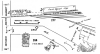
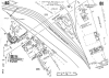
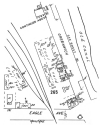
I discovered a circa 1965 Canadian Underwriters Association Fire Insurance Map at the main branch of the Brantford Public Library. Sections of the 1965 maps are shown in Figures 2 through 4.
Figure 2 shows the area around the station on Market Street. Note how the map shows the tracks in the yard diverging (just above the number "277"). This arrangement of track is not apparent from the schematic shown in Figure 1.
Figure 3 shows most of Brantford Yard. Again, note the alignment of the yard tracks that is not apparent in Figure 1. The location of the track scale is clearly shown. The triangular building flanked by sidings and labeled "Sash Factory" still exists.
Figure 4 shows the area at the east end of Brantford Yard at Eagle Avenue. The coal bins (immediately above the number "265" are still in place today, but the business here is now an engine repair shop. Figure 1 shows a siding at this location - I believe the siding ran along the back of the bins. The foundation of the structure labeled "24B" is still visible today. The water tank was located on Eagle Avenue behind the small structure on the corner labeled "235A".
Even though the fire insurance maps date from 1965, they help "put a face to" the industries named in the earlier schematic diagram. Even though these maps are a good ten years outside of the era I wish to model, they help show how the yard was used, and where the industries were located and the types of industries that clustered around and in the yard. I feel it is very likely that many of the industries that appear in the schematic and the fire insurance maps likely date back to the era I am interested in - the coal dealers in particular.
For determining where industries were located and what the structures looked like, fire insurance maps are an incredible resource. They were updated every few years, so access to a good set of maps spanning several years can provide a lot of information on how an area and its industries evolved.
The collection of maps has been the primary focus of my research so far, and they have allowed me to assemble the layout plan shown here. In order to better understand how to operate the layout, I am now working on research into the industries served by the railway. As I learn more of the history of Massey-Harris, Cockshutt and others - their corporate histories, technological developments, marketing and products - I hope to assemble a realistic scheme for operating the layout: as these companies grew and changed, presumably the way the railway served the companies also changed.
The Layout
The space I have available is rather small - just 10-by-12 feet - so Brantford Yard in HO (1:87) scale ends up being quite compressed. I wanted to keep the "open" look of the yard suggested by the track alignments shown on the fire insurance maps, and at the same time, retain as many of the local industries and "signature scenes" as possible. The important "must have" scenes include the water tank at Eagle Street, the scales, crane track and ramp in the yard, and the station and shed at Market Street.
Functionally, I considered it important to have a working C.N.R. interchange and some representation of the Waterous switching. These items are combined as shown on the plan: two sidings, one for Waterous and one for C.N., that disappear behind building flats representing the Waterous structures. Unfortunately, this is the best that can be done in such limited space - which is too bad, as the Waterous plant itself would likely make for a fascinating model.
Although not drawn precisely to scale in the plan, there should be room for a full-scale model of Brantford Station. In its post-1906 expansion form, the station was a beautiful building, and it deserves to be modeled faithfully. The shed - labeled as "Farm Equipment Storage" in Figure 2 and likely originally the station's freight shed - will be modeled in a compressed form.
I have tinkered with the idea of adding some switching on a removable shelf in front of the closet door to represent the Massey-Harris plant on Market Street, but I doubt this will come to pass - I am likely to have enough problems with the staging yards!
I have drawn perhaps a dozen different arrangements for the staging areas indicated on the plan, but none of them seem to work - so I'll just allude to them with an ominous dotted line.
Part of my problem with the staging design is that I have yet to find any information on operations in the early decades of the 20th century - I am not at all certain as to how trains were run on the Waterford Sub, or how many trains ran per day.
Lance Brown has posted information to the TH&B mailing list regarding more modern operations, but I have the feeling that operations were rather different when Brantford was in the golden age of the Canadian agricultural industry.
Naively, I am assuming that Brantford of this era would see four freight trains and at least two passenger trains per day. If anyone has information on how the Waterford Subdivision was operated in the early years of the century, please write to me in care of Focus.
I probably have the number of trains wrong, but with proper staging, four trains in a 24-hour period might be an interesting number to juggle on the layout. Certainly during the war years Brantford must have seen traffic levels similar to those I have in mind.
One thing I am fairly certain of is that the staging yards will require the ability to turn locomotives, vans and entire passenger trains to represent what was done with the equipment at Waterford.
So Am I Out to Lunch, or What?
In wanting to represent nearly half a century of activity, I'm making quite a few assumptions about how Brantford Yard looked and worked by basing the design on just two sets of maps! Any information anyone can offer about the appearance and workings of Brantford Yard or the industries in Brantford would be greatly appreciated. Please feel free to write to me in care of Focus to offer additional information or - if it's needed - set me straight on any naďve assumptions I've made in the design!